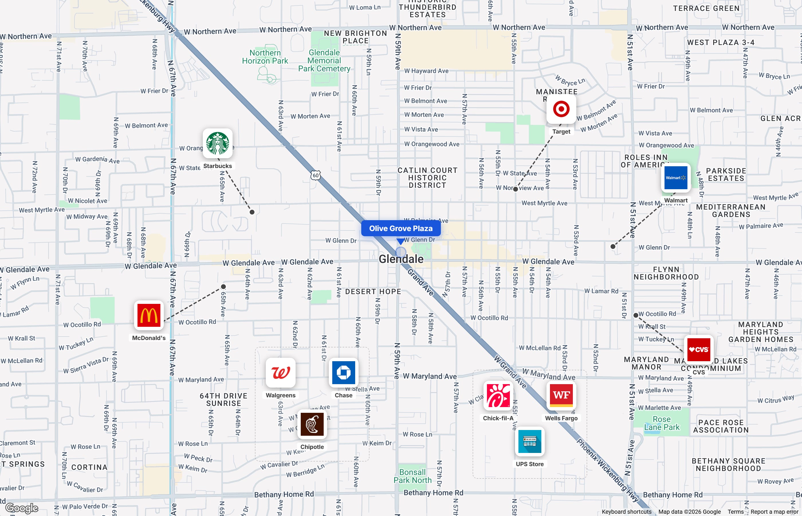
A great location map can be worth a thousand words in a commercial real estate marketing package. Instead of screenshotting Google Maps and pasting logos in PowerPoint, CREBuilder's Map Builder lets you create professional aerial maps directly inside your documents.
This tutorial walks you through the map creation process from start to finish.
Why Location Maps Matter
When an investor evaluates a property, they're not just looking at the building — they're evaluating the trade area, neighboring tenants, traffic patterns, and demographic context. A well-designed aerial map communicates all of this at a glance.
Professional maps with tenant logo overlays instantly convey:
- Trade area strength — recognizable brand logos show the quality of neighboring tenants
- Accessibility — proximity to highways, intersections, and major roads
- Area density — surrounding development patterns and population centers
- Competitive context — how your property fits into the broader retail/commercial landscape
Getting Started
The Map Builder is accessible from the document editor when working on any page that includes a location map — typically the Location Highlights or Demographics page.
Step 1: Set Your View
The map centers on your property address automatically. From there, you can:
- Zoom in or out to show more or less of the surrounding area
- Switch between satellite and street views — satellite shows the physical landscape, while street view emphasizes road networks and labels
- Pan to adjust the exact framing you want
Tip: For most retail and commercial properties, a zoom level that shows a 1-2 mile radius provides the best balance of context and detail. Too close and you lose neighborhood context; too far and the property itself becomes hard to identify.
Step 2: Add Tenant and Amenity Logos
This is where the map comes alive. Click to place logos on the map for:
- National retailers near the property (Target, Walmart, Starbucks, etc.)
- Restaurants and food service (Chipotle, Chick-fil-A, etc.)
- Banks and financial services
- Grocery anchors (Whole Foods, Trader Joe's, etc.)
- Healthcare facilities
- Entertainment and fitness
The logo library includes hundreds of national brand logos. Place them at the actual location of each business to create an accurate representation of the surrounding tenant mix.
Step 3: Customize the Presentation
Fine-tune the visual presentation:
- Adjust logo sizes to create visual hierarchy — anchor tenants larger, smaller tenants appropriately sized
- Hide map labels to reduce visual clutter (hides POI and transit labels while keeping road and city names)
- Position your property marker prominently at the center
Step 4: Save and Embed
Once your map looks right, save it and it's automatically embedded in your document. The map appears on your Location Highlights page and can also be used on the Demographics page if your document includes one.
Best Practices for CRE Aerial Maps
Show the Right Radius
Different property types benefit from different map scales:
- Retail / Restaurant: 0.5-1 mile radius — focus on immediate trade area and co-tenancy
- Office / Medical: 1-2 mile radius — show highway access, amenities, and nearby employment centers
- Industrial: 2-5 mile radius — emphasize highway/interstate access, port proximity, and logistics infrastructure
- Multifamily: 1-3 mile radius — show schools, transit, grocery, and lifestyle amenities
Prioritize Recognizable Brands
Not every business near the property needs a logo on the map. Focus on:
- National credit tenants that investors will recognize
- Major anchors that drive traffic to the area
- Complementary uses that enhance the property's appeal
Five well-placed logos tell a stronger story than twenty cluttered ones.
Use Satellite View for Most Properties
Satellite imagery shows the actual built environment — parking lots, building footprints, landscaping, and open space. This gives investors a much better sense of the physical context than a flat street map.
The exception: for properties in dense urban areas where building footprints all look similar from above, a street view map with clearer road labels may be more informative.
Keep It Clean
Resist the urge to add too many elements. The best location maps communicate the key message quickly:
- This is a well-located property
- It's surrounded by quality tenants and amenities
- It has strong access and visibility
If the map feels cluttered, remove the least important logos until it reads clearly at a glance.
Maps Across Document Types
The Map Builder integrates across all CREBuilder document types:
- Offering Memorandums — Location Highlights and Demographics pages
- Sales Teasers — Combined property highlights section
- Leasing Packages — Area overview for prospective tenants
- For Sale and For Lease Flyers — Location context in a compact format
The same map data is shared across all documents for a property, so you only need to build it once.
Try It Yourself
The Map Builder is included in all CREBuilder plans, including the free tier. Start a free trial and create your first aerial map in minutes — no design skills required.
For more details on the Map Builder's capabilities, visit the Map Builder feature page.